Cruising Past Seventy: The Inner Journeys: Yukon
Showing posts with label Yukon. Show all posts

Tuesday, August 20, 2024

There’s Absolutely No Reason for Breaking Rules When We Travel


I“It’s just for a photo.” “It’s just a tiny piece.” “It’ll just be for a second.” Those were some excuses I used when I violated a rule to get a thrill. Now at 75, I know there is no place for this. 

Snow and Ice in the Yukon 

On the way to Whitehorse, the biggest city on Alaska Highway, between Upper Liard and Rancheria, we saw rocky embankments with many names of people assembled from rocks.  We had just come from the Signpost Forest where ours became the 67,000th addition. I was in the “leaving signs mode” so I pleaded with Bill to stop.  When he did, I quickly collected some rocks and began to form the letters of our names. Bill followed. But it was so time-consuming that we just did two letters: B & C, not British Columbia, not Before Christ, but Bill and Carol. 

Then I saw the sign. It said, “Take nothing but pictures. Kill nothing but time. Leave nothing but footprints.” It was too late. I had already committed the crime. Later, I learned that the warning was to prevent people from displacing too many rocks because that would weaken the wall built to protect the road from onrushing snow or ice.   

The Glaciers of Alaska 

A week later en route to Valdez, Alaska, I remarked “Gosh, the glaciers are puny around here.” There were just tiny patches of white. A few minutes later, as our 24-foot Class C RV was negotiating a bend on the road, a white glistening mountain loomed larger and larger. It was Worthington, a 113-acre road-accessible glacier on Richardson Highway. 

Bill was ecstatic, parked the RV, and began to climb the ice mountain. As usual, I was not as inclined to risk the slippery slopes and shouted for him to bring back a chunk of the glacier. He did. But it was too late when I realized it was quite foolish to break another golden rule, for a block of ice that will not last long anyway and only hug valuable prime space in our RV’s tiny freezer. 

The Littlest Penguins of Australia 

Another opportunity to break another rule presented itself in Melbourne, Australia while I was babysitting my youngest grandson. Every weekend when the young parents were home, I went out to see some sights. One of my first outings was to Philip Island, only a one-and-a-half-hour drive from Melbourne. It’s the home of the world’s littlest penguins, about a foot tall. 

The ranger explained that the penguins waited for dark before they came in after feeding in the ocean. They waited for each other about a hundred meters from shore and waited to form a group for more security against birds of prey. At 5:49 pm, when there were eight of them, they slowly walked into the space between the two viewing platforms. The ranger repeated the rule: No Photography Allowed. But I couldn’t help it. It was the cutest sight. I took a shot.  

The ones who did not swim to feed came out of their burrow to join those who did. Soon they were all around, under the boardwalk. I could not help myself and took a few more shots. I thought I was going to get away with my crime, until a ranger approached me to say, “The penguins do not do well with the light coming from cameras.” I felt so ashamed. I was almost seventy but still unable to follow the rules. 

They are not made to be broken. They are there for a reason. You will be horrified at the consequences when they are not followed. Just look at the tons of plastic floating on the Pacific Ocean. There’s no reason for breaking rules when traveling. There is no reason at all, even when you are not traveling.


Friday, August 12, 2022

TRAVEL AWAITS: 8 Best Stops Along an Epic Yukon Arctic Road Trip During The Fall


The full article was first published in Travel Awaits on June 16, 2021

My husband and I have been traveling for 14 years since the time we met and married. And whenever we are asked the question “What is the most memorable trip you have ever taken?” our answer is still, after all these years, the same. It happened because we wanted to go back from Fairbanks, Alaska to Seattle, Washington on a different route from the way we came up from Calgary, Alberta. That was a consequential decision because it led to our epic Yukon Arctic Road Trip. That it was almost fall added to the color and the spectacle. Let me tell you this once-in-a-lifetime story.

Chicken, Alaska


After a short visit to experience Christmas in September in North Pole, Alaska, we were ready to go back to mainland USA. But we thought of not going back not on the same Alaska Highway. Instead, we found an interesting diversion: east to Chicken, Alaska, and the Top of the World Highway to the historic City of Dawson Yukon before going south on Klondike Highway that drops down to Cassiar Highway in British Columbia.

The road to Chicken, Alaska was all gravel, a prelude to our next several days of travel.  The town’s summertime population was 32 at the time (wintertime, seven). It got its name because the residents could not spell the word “ptarmigan,” the actual inhabitant.  This was the most rustic camping we had to date. There were two campgrounds, one with gold-panning activities up the hill and the other with the country store down below.  We chose the former and were rewarded with a spectacular sunset.

Top of the World Highway


This 79-mile-long highway begins at a junction with the Taylor Highway and travels east to Dawson on the western banks of the Yukon River in the City of Dawson. It has been in existence since 1955 and is only open from mid-May to mid-October, sometimes not even. It is one of the most northerly highways in the world. Two farther north, the Dempster Highway and the Dalton Highway, both lead to the Arctic Circle.

The Top of the World Highway deserves its name because it skirts the crests of endless mountains, giving only random peeks of the valleys below. Since the highway is above the tree line, the whole route was devoid of trees. We got a preview of this kind of alpine tundra in Denali National Park. But, here it was in great splendor, resembling an expansive carpet of red, orange, gold, and yellow that covered the undulating mountain tops, setting it apart from the great big, blue sky.


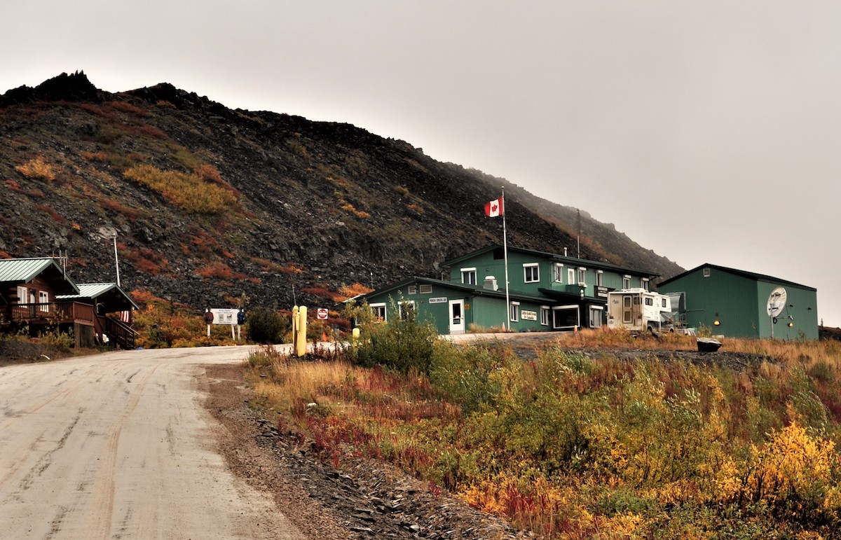
The Poker Creek - Little Gold Creek Border Crossing was open (pre-Covid) during the summer months from 8 am to 8 pm (Alaska time). It was unlike any other border I have seen. There was nary a soul, just my husband, the immigration officer, and me. And soon after, we reached the highway terminus where a ferry connects West Dawson to Dawson in summer (the residents use an ice bridge in winter). My husband and I, Star (our RV) and Vino (our scooter), rode the small ferry. Such exciting times!

Downtown Dawson

The City of Dawson is inextricably linked to the Klondike Gold Rush (1896–99). It served as Yukon's capital from the territory's founding in 1898 until 1952, when it was moved to Whitehorse. During its heyday, there were about 40,000 living in the city but now the population stands at only 1,375. Even then, it is the second-largest town in the Yukon, that part of Canada that is remote, pristine, and sparsely populated, just like the two other Canadian Territories, Nunavut and Northwest.


But its “golden” past is kept alive by colorful saloons, thriving general stores, and old theaters in the architecture of its historic past. All new construction must comply with standards to ensure this appearance. This historic core of the town is a National Historic Site of Canada. Every February, Dawson acts as the halfway mark for the Yukon Quest International Sled Dog Race when mushers do a mandatory 36-hour layover to prepare for the second half of the world's toughest sled dog race.

The town is so interesting that the area around it is also featured prominently in the novels and short stories of American author Jack London, including his classic, The Call of the Wild. The famous writer lived in a rustic Dawson cabin up the hill from 1897 to 1898. Surprisingly, it was side-by-side with another cabin, the one owned by the Canadian poet Robert Service. A great find for us.


Sites of the Klondike Gold Rush

It is also in the area when, in the spring of 1898, gold was discovered in nearby creeks. Thousands arrived and the famous Klondike Gold Rush began. Later, large gold dredges started an industrial mining operation, unearthing large amounts of gold out of the creek s. The landscape changed, the creeks shifted, and a network of canals and dams were built to produce hydroelectric power. The dredges shut down for winter, except for Dredge No. 4 which is now the Klondike National Historic Site of Canada. That’s where we saw what they claimed to be the largest gold steam shovel in the world.  Dawson was definitely worth the diversion.


Dempster Highway

Except for the fact that I was so disappointed I did not get to witness the Aurora Borealis there. So the day we were to leave for Whitehorse to resume our trip back to the lower 48, I pleaded with my husband to go north instead, up the Dempster Highway to the Arctic Circle. We passed up the opportunity in Fairbanks, Alaska, even though Dalton Highway is shorter and better. I told him we will probably regret it if we did not do it; only about 3 days and 2 nights separated us from the bragging rights.

Luckily, he agreed even if he knew it would be a rough journey, especially since we had an old second-hand 24-foot RV. The Dempster Highway is a 457-mile road that connects the Klondike Highway in the Yukon to Inuvik, Northwest Territories (now there is even a new highway that extends to the Arctic Ocean). It was a dirt-gravel road; rocks were put together and sealed/packed by mud. My husband said that if it looked like Star would not be able to handle it, then we would just go back. But we didn’t. Many times we had to slow down to 5 mph, averaging about 25. At the end of the trip, Star had to have all her shocks replaced. But it was all well worth it.


Tombstone Territorial Park

Crossing the Ogilvie and Richardson mountain ranges had been a succession of one beautiful scene after another, as the trees of the valley changed into shrubs of the subalpine hills and into the moss, lichens, and fungi of the alpine tundra, all in blazing fall colors. Every fifteen minutes, I would ask my husband to stop for yet another spectacular view. The day after, going down from the Circle, the colors seemed even more vibrant, more of everything had simply turned brighter yellow.

\

Everything seemed to gather, collect, and distill at the Tombstone Territorial Park. It stands near the southern end of the Dempster Highway, protecting over 2100 square km of rugged peaks, permafrost landforms, diverse flora, and fauna, including Dall's sheep, caribou, moose, and black and grizzly bears. The Park is also a birders' delight, with about 150 bird species identified. A notable feature is Tombstone Mountain which resembles a grave marker, that's why the name. Tourism operators offer excursions into the Park during the summer months. There is an interpretive center as well as several camping sites. But we were simply content with looking at the spectacular scenery.

Eagle’s Plains Hotel and Service Station


And there is even a place where you can rest, on the way up or the way down, halfway between Dawson and Inuvik. Eagle's Plains has a hotel with basic rooms, a cafeteria, a gas station, and several RV spaces.  A storm had developed, the winds were strong, and the cold was biting. But we survived the night in Star because we kept each other warm. In the morning, the sun was shining again.
 

On the way down we chose to boondock at a spot we found near where I saw a Dall sheep grazing at the river bank the day before (headline photo). On the other side of the road was a hill ablaze with red, yellow, orange, and gold. Before nightfall we spent the time looking at the different plants up close, to discover how such a magnificent tapestry was woven. And we were happily surprised to meet a European couple who had also camped the night but farther from the river.

Arctic Circle


We saw an elephant rock atop a hill, fluted whitish mountains, little lakes, colorful carpeted fields, rushing rivers, and all things beautiful. Imagine that this is the land first seen by those who migrated from Asia to North America. It is a beautiful, untouched wilderness, vast and still. When we reached the Arctic Circle-Yukon at latitude 66 degrees 33 north, we were alone at the arch proclaiming that one-of-a-kind spot on earth. It was cold. The winds were biting. We could not stay long. Shivering, we hurriedly put our camera on its timer, placed it on the lone picnic table, and took our once-in-a-lifetime shot. 

FOR THOSE ON MOBILE, SHARE BUTTONS APPEAR WHEN YOU CLICK WEB VERSION AT THE VERY END AFTER COMMENTS.

PREVIOUS POST 

"The Best Things to Do in Seaside, Oregon


Wednesday, May 5, 2010

Spending Summer in Alaska, Part 2-Denali National Park, Fairbanks, North Pole, and Chicken

Denali National Park
We left Cristine, Bill's daughter, in Anchorage with a tinge of sadness in our hearts, knowing that another trip to Alaska will not happen again any time soon. But we were also eager to proceed to Denali National Park, one of the country’s most admired parks. It was established as the first national park to conserve wildlife in 1917.  Its dynamic glaciated landscape supports grizzly bears, caribou, wolves, Dall sheep and moose. And the park is home to North America’s highest peak, the awe-inspiring, 20,320 foot Mount McKinley. At 6 million acres, the park is larger than the State of Massachusetts.


On the way we passed through Wasilla (population: 7,000), the hometown of Sarah Palin.  The normal rumor-mongerers that we were,  we tried to drive around Lake Lucille to chance upon her home.  But we were not lucky.  So we went on to Talkeetna, on the southern end of Denali, where the view of Mt. McKinley was supposed to be best.  Unfortunately, the mountain was hiding from us under the heavy fog cover.  Now we understand that July is the best time to spend summer in Alaska! That night we camped at the nearby Denali State Park, reserving the next 2 at its big brother, Denali National Park.  


a Grizzly on the road
our great bus driver!
The only way to get to the heart of Denali National Park was to backpack or ride the park buses.  The next day we chose a bus that would take us to the nearest point to Mt. McKinley.  Our bus driver did a good job of spotting wildlife for us.  He stopped when a grizzly bear suddenly appeared roaming on the road right in front of us.  Later he spotted dall sheep grazing at a mountain side, a wolf nestled among the grass by the road, and caribous resting down the valley.  From many sides the majesty of the alpine tundra began to unfold before us. Little did we know that it was a prelude to our Arctic experience.

me and the Iditarod dogs on a sled
But when we reached Eielson, the heavy fog behind which Mt. McKinley had been hiding had not lifted at all.  We were denied the spectacle of the ‘High One’ of the 600-mile long Alaska Range.  We could, therefore, not buy any of the merchandise at the gift shop that glowingly said: ‘I am part of the 30% that saw Mt. McKinley’. And even if we stayed a few more nights, the forecast was that it would not clear so we decided to just visit the educational Murie Science Learning Center and the fascinating Iditarod sled dogs training facility on the park and leave for Fairbanks the following day.

view of Mt. McKinley from University of Alaska in Fairbanks 
musk oxen at the Large Mammals Research Center
Fairbanks is the largest city in the interior region of Alaska, and second largest in the state behind Anchorage. The population of the city is over 35,000 and is home to the University of Alaska Fairbanks, the oldest college in the state. The university was the most exciting place in the city.  From a viewpoint on campus, we finally got a glimpse of Mt. McKinley, albeit 100 miles away.  Then, I saw, for the first time, artichoke plants at the university’s beautiful nursery.  But the most exciting part in campus was chancing upon the large muskoxen at its Large Animals Research Station. 

We stopped by the Fairbanks Visitors Center to ask about how we can see the famed Aurora Borealis and a possible trip to the Arctic Circle.  They told us the northern lights will have a greater probability of being seen in about 5 days (it is visible in Yellowknife, Alaska 10 months in a year).  We also found out that the distance between Fairbanks and the Arctic Circle along Dalton Highway is about 400 miles roundtrip while between Dawson City and the Arctic Circle along Dempster Highway in the Yukon is about 500.  I guess we were not ready to take the big leap so instead we went to North Pole, Alaska the following day.
our campground in North Pole, Alaska
Santa at our North Pole, Alaska campground
And there we became kids all over again.  The city and our campground were bedecked with everything Christmas:  Christmas décor hung from all the light posts on the streets, the campground entrance was guarded by  7 reindeer and 20-foot Santa.  Another big Santa with a sleigh was in front of a small park with real reindeer.  Then there was a huge Christmas store on the lot from which we sent Christmas cards to all our siblings, children, and grandkids postmarked North Pole, Alaska.  And, of course, I had my picture taken on Santa’s lap! Truly, there it was Christmas 365 days in a year! 
the Christmas store in North Pole, Alaska

gold panning in Chicken, Alaska
Finally, we decided to go back to the lower 48 on a different route (not the Alaska Highway) this time…through Chicken, Alaska and the Top of the World Highway to Dawson City in the Yukon. The road to Chicken, Alaska is all gravel, a prelude to our next several days of travel.  The town’s summertime population is 32 (wintertime it’s 7).  We understand that the town got its name because the residents could not spell the ‘ptarmigan’.  The town is comprised of 2 campgrounds, one with gold-panning activities and the other with a country store.  We stayed at the former which is up the hill.  There we witnessed a spectacular sunset.  And the following day, we resumed our journey through the spectacular Top of the World Highway.
the country store in  Chicken, Alaska

Next Stops:  Dawson City and the Arctic Circle in the post titled, ‘Venturing to the Arctic Circle’

Wednesday, April 21, 2010

Navigating the Alaska Highway, Part 2

Mama Bear and her cub by the roadside in northern British Columbia
bison by the roadside
Northern British Columbia had some very scenic spots that we chanced upon:  Muncho Lake, Tetsa River, Stony Mountain, Summit Lake, and Liard Hot Springs.  It was in this part of North America where  we saw the most number of wildlife by the road sides: a mother bear and her cub relaxing among the grass and wildflowers, a herd of bison lying on the ground with a huge one walking along the road beside our motorhome, and a moose hiding among the shrubs by the hot springs.  There were no mileposts on the first 1000 kilometers of the Alaska Highway but we started seeing them on the Yukon.   The Highway criss-crossed the British Columbia/Yukon border several times.  So we were primed when we reached Watson Lake, the first city on the Yukon part of the Highway. 
Liard Hot Springs

Signpost Forest
We went to see the Northern Lights Museum expecting to be educated about the Aurora Borealis at $10 each.  It turned out to be just a brief video of the lights recreated on the dome ceiling for effect.  It was not worth the time and money the 3 couples spent on the ‘show’.  But the memorable place in Watson Lake was Signpost Forest where we were the 67,000th visitor to place a signpost.  Ours reads ‘Bill & Carol, Pittsburg, Ks/ Manila, Phil. 8PM, 8/8/08’ which we painted on a wooden board we purchased at a HomeBuilders’ Centre.  The paint was provided by the Visitor’s Information Centre where we also registered as Yukon Gold Passport holders, with the chance to win 5, 10, or 20 troy ounces of gold if we complete 10, 20, or 30 rubber stamps of tourist spots we visit on the Yukon!!!

Bill and Carol on the road embankment
Along the highway between Watson Lake and Whitehorse were rocky embankments (between Upper Liard and Rancheria along the Yukon part of the Highway) that were used by many to arrange rocks into letters to memorialize their passing through the Highway.  We arranged ours to symbolize BC (not British Columbia but Bill and Carol) alongside others.  We originally thought we could spell out our names but we found out how difficult the endeavor was and gave up with just the 2 letters!

Whirlpool Canyon
At another bend we saw a large arrow sign which we followed and chanced upon Whirlpool Canyon, a river that made a whirlpool as it wound its way.  There we met a Canadian couple who also followed the arrow.  They were making their way from Calgary (just like us) going to Nunavut past the Arctic Circle hauling a small aluminum boat with an outboard motor to fish.  They dry camped often and they taught us about dumping gray water (washing dishes and showering) almost anywhere and drinking creek water, as long as we were sure there was no beaver contamination.  A small town we passed was called Toad River.  It featured a gas station, a restaurant, and a country store.  There was a place there dedicated to thousands of hats and Bill pinned his Taquan Air baseball cap which he got from a private charter company in Sitka, Alaska where he went for a fishing expedition with friends in 1999. At this part of the Highway, gas was at $4.50 per gallon!

World's Largest Weather Vane
SS Klondike of the gold trade
Whitehorse is the biggest city in the Yukon.  The largest weather vane (in the Guiness Book of Records) in the world was there.  It was a DC3 plane!!!  Bill thought that it has to be a very strong wind (at least 10-15 knots) to move that plane. Smith House at Whitehorse’s LePage Park gave us 2 whitehorse pins to brag about, but so man y places, including the biggest fish ladder in the world, was already closed for the season.  So we didn’t see the salmons jumping out of the river to spawn!  We had to be satisfied with the SS Klondike, one of the biggest boats used for transporting gold to and from the Yukon River.  And the experience that topped it all?  We feasted on the world-renowned bowl of chili con carne at Tim Horton’s, the great Canadian coffee chain! Claudine (my second daughter) had gifted us with a Tim Horton’s gift card before we left Calgary…and they had it in Whitehorse!
                  .
Burwash Landing @ the Yukon
 The unfortunate thing was smoke fire from Whitehorse thru Haines Junction to Beaver Creek (50 fires around the Yukon since it had been so hot and dry that summer) stole all our beautiful scenes.  We could hardly see anything beyond the nose of Star! Burwash Landing was almost wiped out by a huge forest fire caused by humans camping (although lightning is the more common cause). 

Another unfortunate thing was the perennial damage caused by permafrost effects on the Alaska Highway, especially after Destruction Bay.  The cost of maintenance must be high.  There are always many road fissures and small ponds on the fields along its sides.  The highway had a roller coaster feel to it and evergreens in nearby fields could not grow any taller than a few feet.  Orange flags were everywhere, designating permafrost damaged areas.

Mount Churchill and White River 
And then there was White River, colored off-white due to volcanic ash from two successive (in geologic time) pyroclastic eruptions of Mount Churchill in the Wrangell Mountain Range.  The first eruption occurred in 1890 and the second in 1950. Thick layers of pumice-like ash over 340,000 square kilometers ( 211,276 square miles) severely disrupted food supply and caused the migration of people steadily southward.  The river is not recommended for boating; the ecology could not be restored.

quonset hut church
So camping on the Kluane RV Park in Haines Junction was not what we expected.  At the junction we were supposed to be able to see a glimpse of glaciers in Juneau and also the highest mountain peak of Canada and the Canadian Rockies.  We didn’t, of course.  We also thought we found a great hiking trail near the campground but we returned to our motorhome right away after we found out that the mosquitoes were sooooo hungry!  What saved the day was the discovery of quonset huts that have been turned into churches that could sit 30 people.


the end of the Alaska Highway in Delta Junction, Alaska
 The next day we hurried to resume our trek to Alaska through Beaver Junction, Yukon and Delta Junction, Alaska which was the official end of the Alaska Highway!  The signpost at the Visitor Center reads:

This highway was constructed during World War II as a military supply route for interior Alaska Military and Airfields in 1942. 7 Army regiments and 42 Contractors and Public Roads Administrators working from Delta Junction South and Dawson Creek North completed it when they met at Soldiers' Summit at Kluane Lake Yukon Territory in November 1942. At the peak of construction, 77 Contractors employed 15,000 men and 11,000 pieces of road building equipment. The total construction cost for 1422 miles was $115,000,000.
      

Next Stops:  Tok, Valdez, Anchorage, Homer, Seward, Fairbanks, and Chicken, all in Alaska 

Wednesday, April 14, 2010

Navigating the Alaska Highway, Part 1

Star at the entrance to the Alaska Highway
Okay, we had been back from the Philippines, visiting my youngest April, and Taiwan for 2 weeks, we had rented out our townhomes and sold our belongings, and we had bought Star and Vino.  So we left my eldest Trisha and her family in Seattle, visited Bill's eldest Jim and his family in Boise, Bill's second child Suzanne and her family in Denver, and my second child Claudine and her family in Calgary, and we are now headed for Jasper National Park, then the famous Alaska Highway, and on to see Bill's youngest Cristine in Alaska before we get back down to the lower 48 and Mexico!  This is it!  This is the start of our RV cruising life. 

We had been to Banff before.  After all, it is only about an hour away from Claudine’s home and we have visited Claudine a number of times.  The Canadian Rockies is often called the Alps of North America, much more beautiful than the Rockies in the USA.  Banff is surrounded by alpine peaks eternally covered with snow.  So is the new town of Canmore, fast becoming another tourist destination in the region, second to Banff and picture-perfect Lake Louise a little further ahead.  But we were more interested, this time, in Jasper, deeper into the Canadian Rockies.

@ Icefields Parkway
We were driving along the Icefields Parkway, reputed to be one of the most scenic highways in the world and all of a sudden it hit us!  The purple mountain majesties turned into high white spaces.  Huge glaciers that were endlessly interconnected draped the boundless boulders.  This is the Columbia Glacial Fields where you can ride on those huge buses that can ply the ice fields.  We do not know what else lies before us.  If this is any indication, we will be in to some parts of this world we hardly know about.

a lake in Jasper National Park
Jasper National Park is indeed a landmark of beauty.  The lakes were elegant in glacial waters of milky greenish hue.  And there were lakes galore…Medicine Lake, even one called Patricia Lake,… etc.  There were many tourists around.  After all, it was July.  But it felt like you were alone amid the serenity of the lakes and the snow-covered mountains that protected them, in varying hues of blue and purple.  Each photo we took seemed to emerge as another painting!  There is indeed a Master Painter!

elk by the road
We also saw the first wildlife of our cruise…the ubiquitous elk.  Two of them were cavorting by the road and we took endless pictures.  We were on the way to the aerial trams that were supposed to give us even a better view of the unique landscape.  Unfortunately, it was out of order and we were just refunded our tickets.  So we decided to take a trip to Mt. Robson, the highest summit of the Canadian Rockies at over 14,000 ft!

Mt. Robson
The trip took us to the border of Alberta and British Columbia.  At the border was the sign for the first Intercontinental Divide we would cross…and there would be many more.  I don’t know why.  But the peaks of Mt. Robson evoked a secret admiration in me.  They stood as imposing as the Mt. Rainier’s peak, for example, even as they rested on a base that was already thousands of feet above sea level.

Before we left Jasper, we had already bought the Canadian Pass so we could visit all its national parks.  It cost so much more, however, ($150 for a year) compared to the Senior Pass Bill had for the American counterpart ($10 lifetime).  But, what is that compared to the wondrous feelings they will constantly evoke?  It was cheap! And so we left Jasper a little sad but confident that many more wonders await us.  

Mama Bear and her cub by the roadside
As a matter of fact, the trip through northern British Columbia and the Stone Mountains was extra memorable for me because by the winding roads (that would bring up to the Alaska Highway) were my first close encounters with wildlife I had never before seen except perhaps in zoos!  We found a mother and baby bear sitting quietly among the grass, a herd of bisons lying peacefully by the road side (with one of them almost dangerously walking alongside Star), a big moose by a pond on hot springs and a multitude of birds and insects by the raging river we chanced upon following a small arrow sign.  

Mile 0 o the Alaska Highway
Indeed when we reached Dawson Creek, British Columbia, Mile 0 of the Alaska Highway, we could not contain the excitement in our hearts.   Dawson Creek is a small and sleepy town but their bragging rights were all over.  We had a ball taking pics of ourselves at various Mile 0 signs.  We did it…another milestone in our cruising life.  A bonus was at church, I found out that there were about 300 Filipinos living there!

The next town on the Alaska Highway was Fort Nelson, British Columbia.  There we found a museum of the history of the famous highway, how the US and Canada cooperated in its building, and how they separate the maintenance responsibilities at the present time.  Bill and I thought, after navigating the entire length of the highway, that the American portions were better kept than the Canadian part.  The 1,390 mile-long highway has long served the distinct purpose of connecting Alaska to the lower 48, militarily strategic in WWII and economically so now.  But we also think it serves another major purpose:  develop tourism in Canada, especially the vast, underexplored Yukon Territories!  
  
Next Stops:   YUKON TERRITORIES, CANADA: Watson Lake, Whitehorse, and Haines Junction 

Thursday, February 25, 2010

Venturing into the Arctic Circle

We had just traveled the Top of the World Highway from the town of Chicken, Alaska (population in summer, 32; in winter, 7) to historic Dawson City, the former capital of the Yukon during the Gold Rush. It was a magnificent journey; all that you see during the trip are endless mountains that are golden with alpine tundra in the fall, red, orange, gold, and yellow and the great big, blue sky. The US-Canada border at the Top of the World was unlike any other border town, with nary a soul, just Bill and me and the immigration officer.

To reach Dawson City, all of us, including Star and Vino, rode the ferry. Once there we were surprised to find that the log cabins of 2 famous authors, Jack London and Robert Service, were almost side by side on one street. The city’s ‘golden’ past is kept alive by colorful saloons, thriving general stores, and old theaters in the architecture of the time. We even found the largest gold steam shovel in the world, testament to the town’s importance in gold mining history.

But the day we were to leave for Whitehorse to resume our trip back to the lower 48 through the Alaskan Highway, on impulse we decided to go up the Dempster Highway and drive to the Arctic Circle. When we were at Fairbanks we passed up the opportunity, though the road there was shorter and better. We just told ourselves, we will probably regret it if we did not do it, as only about 3 days and 2 nights separated us from the bragging rights. Besides the forecast of the probability of seeing the Aurora Borealis was good for the next few days where we were.

So we braced ourselves for the rough journey, comforting ourselves that if it looks like Star would not be able to handle the roads, then the option of going back was always open. But we didn’t. Dempster Highway was really what they technically call a dirt-gravel road where rocks are put together and sealed/packed by mud. Some parts were so rough you had to slow down to 5 miles per hour. The fastest Star went was 40; average was probably 25. At the end of the trip Star had to go to the doctor. All her shocks had to be replaced. But it was well worth it.

Going up to the Arctic Circle was a gradual succession of one beautiful scene after another, as the trees of the valley changed into shrubs of the subalpine hills and into the moss, lichens and fungi of the alpine tundra, all in blazing fall colors. We had not seen anything like it before. Some semblance of it was at Denali National Park; more at the Top of the World Highway. But here it was in full regalia. Only a day after, going down from the Circle, the colors seemed even more vibrant, more of everything had simply turned bright yellow.

On the way up we stayed at Eagles’ Nest. A storm had developed, the winds were strong, and the cold was biting.But we survived the night, we kept each other warm, and the sun was up and shining again in the morning. On the way down we chose to stay at a spot we found near where I saw a dall sheep grazing near the river bank the day before. On the other side of the road was a hill ablaze with red, yellow, orange, and gold. Before nightfall we spent the time looking at the different plants up close, to discover how such magnificent tapestry was woven.

The beautiful vastness held our voices silent many times those 2 days. We even saw an elephant rock on top of a hill, fluted mountains, and little blue lakes. Everything seemed to gather, collect, and distill at the Tombstone National Park. Imagine that this is the land first seen by those who migrated from Asia to North America. I thought Canada is simply one beautiful country, this is what pristine is, and there is really One Master Gardener.

Especially when we reached the Arctic Circle at lat 66 degrees 33 north.  There was no one in sight for miles around. We were alone at the arch proclaiming that special spot on earth. You just know that it is a special place; there were practically no plants for miles before. It was so cold and the winds were biting that we could not stay long.
Shivering, we hurriedly put our camera on its timer, placed it on the lone picnic table and had the photo of our life ‘taken’.