Cruising Past Seventy: The Inner Journeys: October 2010

Monday, October 25, 2010

Driving Down the West Coast: Monterrey Bay and Carmel-by-the-Sea


Yosemite and Sequoia National Parks are definite must-sees in anyone’s lifetime.  But I also got excited about our next stops, what Bill says are quite special places, too: Monterrey Bay through the scenic 17-Mile Drive and the famed town of Carmel-by-the-Sea.  And they were.  It is wine country, too, but the wineries and vineyards were not where we spent our time.  Our days were filled with beautiful scenes.
Monterrey Bay is a bay of the Pacific Ocean, along the central coast of California, south of San Francisco, between the cities of Santa Cruz and Monterrey.   The bay features the Monterrey Canyon, one of the largest underwater canyons in the world, which begins off the coast of Moss Landing, exactly in the center of Monterey Bay. Carmel-by-the-Sea, usually called simply Carmel, is a small town of more than 4,000 in Monterey County, California, founded in 1902. 

On the approach to the 17-Mile Drive is the Lover’s Point, an area of rocks reaching out to the sea and a few cypress trees that drape the landscape.  Further on the Drive, which crosses the million-dollar homes of the rich, cypress trees dramatized the sea-drenched coastline.  One particular tree has stood alone on a rock jutting out into the bay waters, hence its monicker, The Lone Cypress.

Harbor seals populate the rocks scattered around the waters while sea otters gaily play in the sparkles. They cavorted with birds and many spots have been designated actual marine life sanctuaries.  A world-class golf course stands proudly beside the quietly rampaging waves, its golfers braving the gusts for the tee of their lives. And homes brave the forces of nature with rocks that make their roofs sturdier.
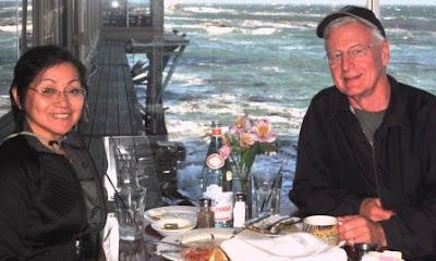
 
Monterrey Harbor had great shops and Bill and I celebrated our lovely days with a special dinner on a restaurant atop the waters.  But the shopping in Carmel was memorable.  The small town had the most elegant shops and fascinating galleries just after the famous Mt. Carmel Mission.  Luckily, one pretty little group of stores had a quaint courtyard where Bill could relax while I took madly to the shelves. 
  
The Mission San Carlos Borromeo de Carmelo was founded in 1770 in the nearby settlement of Monterrey, but was relocated to Carmel by Father Serra a year later and became the new Mission Carmel. The Mission at Carmel has significance beyond the history of Father Serra, who is sometimes called the "Father of California". It also contains the state's first library. The town of Carmel was built around the mission.

Carmel is known for its natural scenery and rich artistic history. Early City Councils were dominated by artists and the town has had several mayors who were poets or actors, including actor-director Clint Eastwood, who was mayor for one term, from 1986 to 1988. In 1905, the Carmel Arts and Crafts Club was formed to support and produce artistic works. After the 1906 San Francisco earthquake the village was inundated with artists from the bay city. Among those who lived in or frequented the village were: Upton Sinclair, Sinclair Lewis, and John Steinbeck

The Monterrey Bay Area is romantic and fascinating.  But the trip through Big Sur was so inviting!

Monday, October 18, 2010

Driving down the West Coast: Yosemite & Sequoia


After Napa Valley and San Francisco, we took a side trip to the famed national parks that sit side by side in east central California: Yosemite and Sequoia National Parks. Though a bit chilly we still felt we struck gold because both were blazing with beautiful fall colors! We freely roamed the hills and valleys with either Star or Vino.  The switchbacks through Sequoia had a 22-ft limit for RVs but since traffic was not that high, 24-ft. Star was allowed through. 


The approach to the heart of Sequoia where General Sherman, the largest living thing in the world, thrives is surprisingly pretty.  We found a tunnel rock which Bill easily climbed.  The view of The Great Western Divide  from the observation ramp on top of the Moro Rock after climbing 400 steps (a World Heritage Site) is truly spectacular! We did not have the time to visit the Crescent Meadows and the Tunnel Log (a giant sequoia that had fallen on a road and cars can pass through a hole carved out of its trunk).

In Giant Forest, where 5 of the 10 largest trees in the world stand, our visit quickly became a comedy because the giant tree we were admiring we later found out was not General Sherman after all! He stood a few meters away, aptly fenced and marked. Standing 275 feet, it proudly stands as a tree that was alive when Jesus walked the earth.  The largest living tree by volume at over 50,000 cu. ft., the diameter at its base is 36.5 feet. In January 2006 a branch fell off from the tree and measured 6 feet in diameter and 100 feet in length, what an ordinary big tree measures! 

Then we moved on to Yosemite.  This park which many consider to be the most beautiful of all national parks was a true delight!  There are three main sections. The fields and clear streams in Yosemite Valley were ablaze with the red, orange, yellow, gold, bronze, brown, and green hues of fall.  Up at Tuolumne Meadows,we still found lots of snow as we stood overlooking the tops of the mountains such as the Cathedral Range (see second photo). At Glacier Point, higher than the mountains, is quite a different but spectacular vista of gargantuan grey granite rocks. Bill bravely stood, upon my beckoning, on one of the cliffs, striking an unforgettably eerie pose! 


The most popular attractions in the Valley are El Capitan, a massive granite rock popular for rock climbing, Half Dome which stands 4,800 feet from the valley floor, and Yosemite Falls, the highest waterfall in North America at 2,425 feet, and Mirror Lake, a serene body of water that reflects the granite cliffs around it. All of these wonders of nature came about when 10 million years ago the Sierra Nevadas were uplifted, tilted and created the deep canyons. Then during the Ice Age, ice as thick as 4,000 feet sculpted the U-shaped valley.


The national park has several campgrounds and many of the amenities and facilities of a small city … department/grocery store, boutiques and specialty retail outlets, movie theaters and auditoriums, lodges, and fine dining restaurants and fast food outlets.  It was fun traveling from one point to another in the valley riding Vino! The wonders of nature are many and even as we exited, a beautiful panorama...a peek of the granite rocks was presented before us at the Tunnel View (actually the first view when you approach the park at its other entrance) .  

We promised ourselves that we will return…next time in spring to see all the colorful wildflowers adorning the hills.

But then Monterrey Bay, the beautiful town of Carmel, and the unique coastal highway, Big Sur beckon!

Monday, October 11, 2010

Driving Down the West Coast: Napa Valley and SFO


We are currently in Spokane, Washington but let me complete our last year’s drive down to Mexico through the West Coast from British Columbia. This Part is about our days of wine in the vineyards and wineries of Napa Valley and our short visit with family and some friends in San Francisco.


Napa Valley slowly emerged as bright sun burnt golden fields after the dreary volcanic landscape of the Cascade Volcanic Arc.  Bill and I happily and appropriately moved from one winery to another driving Vino, tasting great wines, white, red, and rose. Our favorite was El Castillo in Calistoga which rose from the vineyards like a medieval castle in Europe.  Inside were rooms with giant frescoes on the stone walls and courtyards filled with flowers. Topping all these were very entertaining bartenders!


The Valley is widely considered one of the top viticultural areas in all of the United States. By the end of the nineteenth century there were more than one hundred and forty wineries in the area. Of those several still exist in the valley today. In addition to large scale wineries, Napa Valley's boutique wineries produce some of the world's best and award-winning wines. Today more than three hundred wineries are visited by as many as five million people each year.


I know Bill would have wanted to stay there forever but we needed to be in Mexico by November for the annual family reunion so we quickly moved on to San Francisco for a short visit with family and friends and a quick taste of the romantic City by the Bay.  


The City is the 12th most populous in the US, with a 2010 estimated population of almost 900,000.  It is the financial, cultural, and transportation center of the San Francisco Bay Area, a region of more than 7.4 million. It was first established as a fort at the Golden Gate in 1776.  The California Gold Rush in 1848 propelled the city into a period of rapid growth but after three-quarters of the city was destroyed by the 1906 earthquake and fire, the city was quickly rebuilt. 


During World War II, it became the port of embarkation for service members shipping out to the Pacific Theater. After the war, the confluence of returning servicemen, massive immigration, liberalizing attitudes, etc., cemented San Francisco as a center of liberal activism in the United States. Today, San Francisco is renowned for its chilly summer fog, steep rolling hills, eclectic architecture and famous landmarks such as the Golden Gate Bridge, cable cars, and Chinatown

Cherry, my youngest sister, lives there with her husband Ric, a radiation therapist. Zan, her daughter works in the city, too, while Cherry teaches neighborhood grade school kids dance and theater.   Then Bill and I pigged out on sorely missed Filipino dishes and a quick stroll with former co-workers (Fides and husband Benjie and their only grandson and Tess who was later picked up by her kids) from the Institute of Advanced Computer Technology in the Philippines. 

 It was a short visit but I especially looked forward to the next stops in Yosemite and Sequoia National Parks, home of famed wonders of nature, Half Dome, El Capitan, and great falls in Yosemite and General Sherman and other giant sequoias in the latter!    

Monday, October 4, 2010

Driving Down the West Coast: The Cascade Volcanic Arc

*Part of the trip from Canada to Mexico last year, driving down from the Northwest through the West Coast.

I am from the Philippines, part of the Pacific’s Ring of Fire.  Mt. Baker, Rainier, and St. Helens in Washington, Mt. Hood, Bachelor, Three Sisters, and Adams in Oregon, and Mt. Lassen in northern California are all part of the Cascade Range and its Volcanic Arc, also a segment of the Pacific Ring of Fire that includes over 160 active volcanoes. We all remember the Mt. St. Helens eruption on May 18, 1980 which chopped off 400 meters from its peak, replacing it with a mile-wide horseshoe crater. It was the deadliest and most economically destructive volcanic event in the history of the United States.

Our first stop was Crater Lake National Park. The lake is almost 600 m deep at its deepest point with an average depth (350 m) that is the deepest in the Western Hemisphere and the third in the world. This is due to the nearly symmetrical caldera formed 7,700 years ago during the violent climactic eruptions and subsequent collapse of Mt. Mazama and the relatively moist climate that is typical of the crest of the Cascade Mountains. No streams flow into or out of it. It is re-filled entirely from direct precipitation and water is lost from evaporation or subsurface seepage.

Unlike our first time there during the DUs reunion in Sunriver (please see my post on…), this time the lake was in its full splendor…with its deep blue crystalline waters, so clear you can see the deep down under.   At the crater center stands the pretty Wizard Island beckoning us to fly down. Before reaching the crater, however, we were treated to meadows upon meadows of the Pumice Desert, a very thick layer of pumice and ash, largely devoid of plants due to excessive porosity (meaning water drains through quickly. 

As you drive around the lake, you will reach the far end where the The Pinnacles are.  Pinnacles are formed when the very hot ash and pumice come to rest near the volcano, forming 60 to 90 m thick gas-charged deposits. For perhaps years afterward, hot gas moved to the surface and slowly cemented ash and pumice together in channels and escaped through fumaroles. Erosion later removed most of the surrounding loose ash and pumice, leaving tall pinnacles and spires. Bill and I took turns taking photos of each other among these strange-looking proudly standing outgrowths of the volcanically active land.

Just after the Oregon/California border is the Lava Beds National Monument. The Monument lies on the northeastern flank of the largest total area covered by a volcano in the Cascade Range. Its volcanic eruptions created an incredibly rugged landscape punctuated by these many landforms of volcanism. It has numerous Lava tube caves, with twenty five having marked entrances and developed trails for public access and exploration. It is  geologically outstanding because of its great variety of "textbook" volcanic formations including: lava tube caves; fumaroles; cinder cones; spatter cones; pit craters; hornitos; maars; lava flows and volcanic fields.

We got there close to nightfall and the sand hills around the place took on eerily beautiful hues of brown, red, orange, and gold.  This is where we got to use Vino a lot, going from one lava bed to another.  We struck good images, riding that scooter, against the wide spaces of desert land and scenery.  But we also ate a lot of dust. I felt like a new woman, a bike dude kind of woman (see headline photo). Don’t they call them ‘bitches’? At this NP was where I also saw my first native-American petro glyphs on what is left of the Medicine Lake Volcano.  Legend has it that the lake was wide and high enough for the natives to write on its walls.  Of course, now the land is almost dry and the volcano flat. 

Just a hundred miles from the Park was another volcanic wonder, the Mt. Lassen Volcanic National Park.   The dominant feature of the park is Lassen Peak; the largest plug dome volcano in the world and the southern-most volcano in the Cascade Range. The area is still active with boiling mud pots, stinking fumaroles, and churning hot springs. The National Park is one of the few areas in the world where all four types of volcano can be found (plug dome, shield, cinder cone, and strato).

We took a lot of pictures of the venerable mountain.  But we were hurrying through the mountain roads because a storm was forecasted to hit the area and we did not want to be trapped there.  At the end of the road, however, we were treated to a sight that I had never seen before.  Right by the roadside were fumes of smoke rising from the ground.  All around were hills of different hues of red, orange and brown.  It was as if we had reached Yellowstone!

It was already very dark when we found our campground.  There we rested and planned out our next stops:  Napa Valley, San Francisco, San Jose, Yosemite National Park, and Sequioa National Park.