Cruising Past Seventy: The Inner Journeys: airports
Showing posts with label airports. Show all posts

Friday, May 19, 2017

How Saving US$200 on Airfare Turned Out to Be a Major Mistake

the flight I took: China Southern Airlines
Bill seeing me off at Phoenix Sky Harbor
“The Agony and the Ecstasy” is a cliché well appreciated among travelers. After all, we go through the agony of packing and the ecstasy of arriving, of spending hard-earned dollars and enjoying the thrills, of enduring stressful flights and reaching exciting destinations. But this time I really had THE agony. For savings of about US$200, I chose a multi-stop flight combination that appeared as the cheapest in Skyscanner searches. Boy, what a major mistake that turned out to be!

I wanted to go first to Melbourne, Australia to babysit my youngest grandchild and, second, to Manila to visit friends and family, in particular, a BFF dealing with cancer. The cheapest flight included layovers in Guangzhou, China in all segments. I hadn’t been there, and that became a tempting bonus instead of a deal breaker. Unfortunately, I signed up without looking closely at the devilish details. What should have been a 20-hour trip to Melbourne with one stop (LAX)  became a 38-hour ordeal on the first segment alone.

Skytrain at Phoenix Sky Harbor
Right at the outset, the one-hour flight from the Phoenix Sky Harbor International Airport to LAX became all of three hours and a half. The weather in LA was reported as unstable, and Air Traffic Control required that the plane refuels for a potential extended circling over the airport. So, when we finally landed at LAX, I had to rush from Terminal 3 to the Tom Bradley International Airport. I could not find any golf
carts and had to run a circuitous 2 miles because of ongoing extensive construction. I did not want to miss my connecting flight to Guangzhou.  I barely made it in time for boarding. Sadly, the beautiful red and black scarf from Italy, the first gift ever given to me by Bill during courtship, was lost in the mad dash.

I was able to sleep for five hours on the 14-hour flight from LAX to Guangzhou. The other hours
were spent downing two Chinese meals and watching three good movies: Patriot Days, Miss Sloane, and The Founder. But when we landed at the Guangzhou Baiyun International Airport, the simple transfer to another plane involved long queues just like strict immigration lines. Then, as I sat in the waiting lounge, I came to the painful realization that Facebook is indeed banned in China and that internet speeds are extremely slow. I was not able to connect with anybody except for Bill via regular cellular call rates. I was glad I had a portable charger because I was afraid to use the airport’s strange-looking charging stations. 

our plane at Gameco
On the way out of Guangzhou, after all of us were boarded onto the plane, we encountered another two and a half hours of delay, ostensibly because of weather and air traffic control, whatever those meant. But I could not help notice that we were bussed from the waiting lounge way out somewhere beyond the airport terminals to the hangar of Gameco, Guangzhou’s aircraft maintenance engineering section, where our plane was ominously parked. I wondered what they weren’t telling us!  No wonder there was a flurry of activities that delayed our getting bussed by about an hour.

Fortunately, the flight was smooth and uneventful, and I finally arrived in Melbourne. There was minor ecstasy when I found my luggage. She, like myself, had made it through all the running around! It was 50 degrees Fahrenheit at 11:00 pm when Clint, my son-in-law, and I got out to get a cab. Oh, how I missed the scarf that would have kept me warmer. In another 15 minutes, we were at their apartment and Kyrie, my 19-month-old youngest grandchild, was still wide awake. We played until 1 AM with the Play-doh I had brought with me. But it was his pouty lips ready to kiss an old, tired grandma that was the reason why I traveled so far. This was THE ecstasy that came with THE agony!

Kyrie
The US $200 savings is not worth all the hassle. I dread the two other segments, from Melbourne to Manila and from Manila back to Phoenix. They both pass through Guangzhou, and I know I will again suffer the symptoms from Facebook withdrawal. Sigh. From now on, I will limit the flight stops to just one or none and choose the cheapest among those. It is but logical that the hassles will grow exponentially as you increase the number of stops and the end-to-end flight hours. As Murphy’s Law dictates, “Anything that can go wrong will go wrong.” The more stops you make and the more hours you fly, the more things can go wrong! Ergo, simplify!

Thursday, August 18, 2016

A Tale of Two Cities; a Tale of Two Views

Kauffman Center for the Performing Arts, Kansas City
After five months of babysitting grandkids, three in Calgary and two in Seattle, I flew to Kansas City. Bill was waiting for me at the Kansas City International Airport to celebrate the 8th anniversary of our wedding at 8 PM on 8/8/08! But, he didn’t tell me in which Kansas City we would stay! There are two.
courtesy of www.kcpremierapts.com
It reminds me A Tale of Two Cities by Charles Dickens where the main character traveled back and forth on a secret mission from London to Paris in 1775. But there is a big difference. The two Kansas Cities sit side-by-side, as if one, but separately governed. The older city, where I landed, is in the state of Missouri with a population of about 500,000. The smaller with about 150,000 lies in the state of Kansas.

We stayed on both sides. In the first two days, Bill's fraternity brother Ollie and wife Kris welcomed us to their home in Olathe, Kansas, one of the fourteen towns and municipalities in the Kansas City metropolitan area (2.2 m in population).  And that is where we also had our first dinner at Joe's KC, a favorite restaurant specializing in Kansas City barbecue, meat slowly cooked in a wood-fired pit just like in Carolina, Memphis, and Texas.  KC style has slightly sweeter and thicker sauce.

As we went deeper into Kansas City, Missouri, however, we experienced a tale of two views, one that digs deeper into its past and the other that portends the future.

A Tale of the Past

Union Station from the Liberty Tower
City Market
Ollie and Kris brought us to the historic Union Station (established 1914) and from there went to the  City Market, founded in 1857 and still one of the largest and longest operating farmers' markets in the Midwest. Right at its center is the Arabia Steamboat Museum, one of the most popular attractions in the city. It is a unique display of 70 % of the artifacts from the boat and the cargo it was carrying when it sank nearby in the Missouri River in 1856. Five men recovered it in 1987-88 and, with the help of their descendants, four of them operate the museum and are still in the process of cleaning the remaining 30% of the treasures.

the stern of Steamship Arabia
Next stop was the Liberty Memorial, the only museum in the country dedicated to preserving the memory of WWI with the largest collection of artifacts. The global war started in 1914 in a Europe ruled by entangled monarchies and aristocratic families. The US emerged a world power when it belatedly sent fresh troops to the trench war on the western front, turning the tide for the Allies. The war’s end transformed Europe to the consternation of Germany and the other Axis powers. In a sense, it fostered the hatred that resumed the global war 20 years later.

the Liberty Memorial
Visionary leaders of Kansas City raised the funds to build the Memorial just two weeks after the signing of the Armistice treaty in 1918. The tower is 217-feet tall and offers the best view of the city from the top. Two halls flank it, one holding the flags of the Allied nations and the other the names of the 441 Kansans who died in the war. A quarter mile long grassy area with a double row of sugar maples on each side leads to the tower.  In 1998, after four years of temporary closure, a Museum with an East and West Gallery, a theater, and a research center were added. In 2014 the US Congress renamed it the National World War I Museum and Memorial. It taught me well.

The Raphael Hotel
For our anniversary, Bill booked us at The Raphael Hotel, one of the World's Best Hotels for 2015. It is an architectural landmark in the National Register of Historic Places and a member of Marriott's Autograph Collection. It is at the top end of seven hotels in the Country Club Plaza, a privately-owned 55-acre shopping center established in 1922. The first in the world designed for shoppers arriving by cars, it is patterned after Seville, Spain as one of 60 of the World's Great Spaces.

a block of Country Club Plaza
A Tale of the Future

Ollie and Kris were the perfect hosts. Besides delicious meals, comfy bed, and a great home and garden, they also showed us a few of the exciting neighborhoods around the city, like the Latino community on the west side where we had an excellent authentic Mexican lunch.

Sphinxes at the Liberty Memorial
There are two Sphinxes at the Liberty Memorial. One represents the past, with eyes concealed because he did not want to see the horrors. Another represents the future, also with eyes covered because he feared the unknown. But to me, the future represents possibilities.

KCStreetcar
Some of these are already realities like the Streetcar that we rode, taking us from the Union Station to the City Market and back, fare-free! The service opened just last May 2016. Another is The Roasterie with the plane atop its roof, which buys the best coffee beans and roasts them via the best way possible today, air roasting.

The Roasterie
But the best example is the striking modern architecture of the Kauffman Center for the Performing Arts. Moshie Safdie, who also designed the famous Marina Sands Bay Resort in Singapore, created the concept for this Center. Inaugurated in 2006, it quickly became the city icon.  

But Kansas City is no Silicon Valley, After all, it is part of the Midwest where the tale of the future is not as big as the story of its past, just like Kansas City, Kansas is not as big as its Missouri counterpart. But it is also where time stands still as far as incredible human values are concerned. Ollie and Kris are perfect examples. In this little trip, Bill cooked up an excellent way to celebrate our quintuple 8. 

Thursday, December 31, 2015

Our Lifestyle Adventures: We Dared Go to Tunisia!

Bardo Museum in Tunis, Tunisia
2016 starts with this series of posts about the two weeks I spent with my friend Jingjing in nine countries from Oct. 24 to Nov. 7, 2015, most of them in the list of least visited countries in the world. That’s right, nine countries in fourteen days! Another friend Ann was supposed to be with us but could not make it due to personal matters. The two were the drivers of my successful book launch in the Philippines. I arrived at 8 pm in Tunisia from London, and three hours later she did from Istanbul.

Terrorist Attacks
Tunis Carthage International Airport
Tunisia is a name derived from its capital city Tunis which was recently rocked by three terrorist attacks in just eight months. The most recent one, on Nov. 24, killed twelve presidential guards, barely a month after we left! In June, a gunman raided a beach hotel and killed thirty-eight people, thirty of them UK citizens, the worst terror attack against Britons in a decade. The first one was at the Bardo Museum in March when twenty-two were killed. All attacks have been claimed by ISIS.
part of the coastlilne of Tunis
Aside from the Greeks, the Romans, and the original Tunisians, the Arabs conquered the country in the first century of Islam. Then the Ottomans ruled for over three hundred years. The French took over in 1881 but Tunisia gained her independence in 1957. It was only in 2011 when the Tunisian Revolution resulted in the shift to a parliamentary form of government. The only democracy in the Arab World country, Tunisia is certainly still making its way to true stability.
a beautiful girl selling stuff on the highway
We were not supposed to visit Tunisia, the northernmost country in Africa with a population of about 12 million, 98% Muslim, with Arabic as official language (French is also widely used). Marisella, Jingjing’s friend and Filipina wife of the former Italian ambassador to Tunisia, warned us not to go. Alerts were up in most countries, the US included. But I had bought nonrefundable tickets so we still dared to go. I felt safe when I learned of the US STEP which takes care of US citizens in unstable lands. Marisella showed us where to stay and introduced us to Moshen, her trusted driver.

Sidi Bou Said
patio of Dar Said
The expansion of the Tunisian economy in recent decades has led to the booming development of suburbs within the outer city limits. One such suburb, considered a safe place, is the lovely hilly Sidi Bou Said. We stayed at Dar Said, the former home of the Said family converted into a 4-star hotel. I have never stayed in a lovelier place! It was authentic blue and white, traditional decor of an upper-class Muslim home. The lobby led to the terrace with a charming garden that overlooks the Gulf of Tunis and rooms were set around small courtyards. We were served bountiful continental breakfasts by the pool.
one of the small courtyards in the middle of a few rooms
Just before you get into the group of homes on the hill that included our hotel, there is an excellent view of Tunis, Carthage and the Gulf. All the houses in the enclave had the same blue and white motif, blue windows and doors and white facades. And the narrow, winding roads were all cobbled, used by pedestrians and cars alike. One night we enjoyed couscous and lamb at the elegant restaurant, just below our hotel, after a flight of stoned steps to the bottom of the hill.
  
Tunis
a Roman mosaic in the treasured collection of Bardo
Tunis has been the capital since 1159 and is the largest city of Tunisia with a population of 2.7 million. We did not see its famous Medina, a UNESCO World Heritage Site, where 1/10 of its population resides and palaces, mosques, synagogues abound. Because of the situation and also because it was Sunday, the only thing open was the Bardo National Museum, originally a 13th-century Hafsid palace.  It is the most important archaeological museum in the Maghreb, and has one of the richest Roman mosaic collections, thanks to the many discoveries in the surrounding territory.  It also contains mosaic antiquities from various periods in Tunisia’s history. It was where the March terrorist attack was carried out.

Carthage
Carthage Ruiins overlooking the city
Catedral de SAn Luis
The Catedral de San Luis, sitting atop a hill in Carthage, can be seen from the suburbs of Tunis. Although it was closed, all around it was the glory that was Rome, in expansive interior and exterior museums. Tunis had been occupied by the Berbers but in the 12th century BC Phoenicians started to migrate to the country and founded the city. It rose to rival Greece and almost destroyed Rome in the Second Punic War but was eventually defeated by the Romans in the Battle of Carthage of 149 BC. Just a few minutes away is the Thermes, ancient baths. As Mosh drove around, we also saw one of the biggest mosques at the outskirts, marveled at the Sadikas glass display, and shopped for some souvenir items.
Thermes
Hammamet

Marisella also told us not to miss Hammamet, a resort town located in the south east of the northern peninsula  Its many beaches make it an important tourist destination for water sports. The number of inhabitants used to quadruple to 400,000 in summer but the recent terrorist attacks have scared away many tourists. As we made our way to Hammamet, Mount Bou Kornine kept us company. A 576-meter mountain in northern Tunisia overlooking the Gulf of Tunis, it consists of folded and faulted outcrops of Jurassic limestone. Its name comes from Tunisian Arabic meaning "the one with two horns." And that’s how she looks! In ancient times, the mountain was considered sacred and rituals were conducted there.
Mount Bou Kornine
We were scared at first and the November left us shaking our heads more. But we are glad we were able to visit Tunisia despite the circumstances. You can say that Jingjing and I are adventurous souls!


Thursday, November 12, 2015

Our Lifestyle Adventures: Life on Maui's Head

Nakahuloa Head
The island of Maui is the second-largest of the Hawaiian Islands at 727.2 square miles and third most populous at 144,444, behind OÊ»ahu and the Big Island. It is called a "volcanic doublet," formed from two volcanoes that overlapped one another, creating an isthmus between them. Locals fondly call that isthmus the neck. The older Pu’u Kukui is the extinct volcano that created Maui’s Head and had been eroded considerably and cut by numerous drainages, forming the peaks of the West Maui Mountains.
  
VALLEY ISLE RESORT
Although we landed in the east below the isthmus, at the Airport in Kahului, we crossed the neck to get to Valley Isle Resort, our Diamond Resorts time-share, north of the Kaanapali Beach on Maui’s Head. The high-rise resort is designed so that each unit faces the ocean. Our unit had a spacious living, dining and kitchen area complete with all facilities, including a large balcony with a fabulous view of the Lanai Island owned by Larry Ellison of Oracle, about 8 miles from the beach. The bedroom area is equally spacious with a Queen bed, walk-in closet, and a bathroom with a tub. Valley Isle has a pool area but what we were drawn to most was the piece of the coveted beach at the back.

THE NORTH SHORE
On the way to the Blowhole
The next day we decided to see first what was nearest us and drove north on Maui's Head until we reached one of the best beaches on the island, D. T. Fleming Beach. A little further north we chanced upon a family having their pictures taken from atop rocks looking out to the rocky beach below. They gladly took our pictures too. The same lucky thing happened a few turns later. There was supposed to be a Lipaa Lighthouse after this, but we just could not find it! We were frustrated, but soon we were rewarded at Nakalele Point. It is the large area of black rocks featuring Maui’s counterpart to Kauai’s Spouting Horn, the Blow Hole. Oh, what an interesting area for taking photos and videos! But the climb back up was a bit difficult!

NAKAHULOA
The Blowhole
We then traced the coastal road going south on the Head’s eastern shore. It was tricky for it was mostly one-lane. But we were sufficiently distracted because a geological formation that looked like Yosemite’s Half Dome slowly appeared beyond the mountain ridges. We stopped at a few lookouts to take photos, but we could not quite capture the entire Head. Finally, just as soon as thirst was taking over, a food truck miraculously appeared! And behind it was the best view of what we later found out was called Nakahuloa Head. We finally got our beautiful photos and gladly took others’ photos. Just after the truck, we found a tiny settlement, with a pink coffee shop.

IAO VALLEY
Sacred Iao Needle
We had more of this scenic drive on this one=lane road but soon civilization reappeared. We were almost down to the neck again until we saw an arrow pointing to Iao Valley. Hungry, we first stopped at a nearby Mall for locals and split a huge Ramen lunch. Then we resumed our visit to the Valley. It turned out to be a State Park and one of the most sacred spots in Maui. A famous rock formation called The Iao Needle towered over the eastern ridge that surrounded the valley. A raging stream flowed through the middle of the valley floor amid lush native flora. But soon it drizzled, and we had to run to the car, cutting short our discovery walk on such a great find of a Sacred State Park.

LAHAINA
Atlantis
Driving west, we noticed the vast undulating plantations of sugar cane. We understand the pineapple plantations and ranches are there, too, in central Maui. Finally, we reached Lahaina, just south of Kaanapali Beach. The town was Hawaii’s capital until 1845 when Honolulu became the capital.  At The Harbor, there was a multitude of stalls for different water sports. We booked our ticket for the Atlantis Submarine excursion. It was such a thrill as the sign climbed to 150 feet. Then when corals, fish, and even a sunken ship appeared, I was glad I gave it a try. I don't swim, snorkel or scuba so this was the only way for me to see life in the sea.
The heart of the Banyan Tree
Right in front of that Harbor is the Banyan Tree Park where an old Banyan Tree at the center has extended with branches and root systems throughout the park. We had fun taking our pictures in and around those intricate growths. And across the street stood the Baldwin House, the home of Dwight Baldwin (1798–1886), an American Christian missionary and physician during the Kingdom of Hawaii when King Kamehameha ruled. Baldwin founded some of the largest businesses in Hawaii.
Kino's by the sea
The center of activity in Lahaina is Front Street, parallel to the coast and lined on both sides with restaurants and shops. After rejecting many t-shirts in countless shops, I finally found the tank top that declared “I Left My Heart in Paradise” with a map of the Hawaiian Islands in a pink heart! Then we turned to look for where we could dine by the sea. Although there were no tables available in the main dining area of Kimo’s, we found one at the Bar Area. The Steak and Wedge dish was great, but the Hawaiian music from a guitarist and a saxophonist was better, especially since I “almost sang” with them. But it was the glorious Maui sunset glowing from our table that was best!
Hawaiian Medley
We went back to our Resort completely satisfied with the Life we found on Maui’s Head. We hoped that our week would go by ever so slowly here in Paradise!

Thursday, October 29, 2015

Our Lifestyle Adventures: A Wet Aloha in Kauai, Hawaii's Garden Isle

a wet Aloha welcome
We landed in Honolulu at 6 pm under heavy rain. Oh no! The Hawaii sun will be absent during our 17-day Hawaiian getaway, and I had nothing but tank tops and shorts! The hotel shuttle took only five minutes to bring us to our rest for the night. Alas, the pathway leading to our room was flooded so we went to the Chinese restaurant on site for some hot food. Good that, after dinner, the water had receded, and we went straight to our room and bed. Our flight to Kauai was at 5 am the next day!  
Topographical map of Kauai
Kauai is the fourth largest of the Hawaiian Islands at 563 square miles, almost as wide as it is long. It is also the fourth most populous with more than 65,000 people, after Big Island, Maui, and Oahu. We landed at Lihue Airport on the East Shore. Although the rains had not stopped, we were welcomed by the Welcome Landmark on Kuhio Highway. Aloha means a combination of Alo, sharing in the present, Oha, joyous affection, and Ha, life or breath of life. I felt surer of a good time in Kauai.

EAST SHORE

Filipino Memorial
Too early for check-in, we proceeded to downtown Lihue.  At 7 am nothing was open except McDonalds. Good thing they served spam and eggs, the traditional Hawaiian (and Filipino) favorite. I just knew I was going to love the food in Kauai! After breakfast, we visited the Kauai Museum, just a stone’s throw away. Beside it was the County Courtyard. On one side stands a Memorial to Japanese settlers while at the other, the statue of Jose Rizal, our national hero. The two nationalities comprise Hawaii’s top immigrants.

When we got to Pono Kai Resort, our room was ready. It was a one-bedroom unit, the most spacious of the Diamond Resort timeshares we had been to thus far. We were on the ground floor, and the living room led to the exquisite tropical garden surrounded by about twelve buildings of four floors with about twenty-four units each. In the middle of it all, there was a pool, jacuzzi, and lanai. Towards the front were two tennis courts, a putting green, and a fitness center. Behind the last row of condo buildings, a lovely beach was waiting for Bill and me. Everywhere you can see chickens running around!
Our building in the background, Pono Kai Resort
Opaekaa Falls
They say Kauai has from ten to a hundred waterfalls, depending on how hard it rained the day before! Since it had been raining hard, the next day we trekked to see the nearest one. It took only 15 minutes to get to the Opaekaa Falls, 150 feet high, fondly called the Lace Falls because of the delicate pattern the falling waters create. It was a bit far from the Lookout Point though so the second one excited us more, just another 10 minutes away, 80-foot tall Wailua Falls. It was right there below the bridge, and the mad rush of water was truly thunderous that day.
Wailua Falls
Wailua Heritage Trail
The East Shore is called the Royal Coconut Coast. It stretches between the Wailua Golf Course, heading north along the coast to Kealia Beach and up west towards Mount Waialeale. Acres of coconut trees are along the coast and Highway. Even the golf courses preserve them. The area includes the sacred Wailua River, and the Wailua Heritage Trail is host to many heiaus or holy places for the Ali’I, Hawaiian royalty of the former Hawaiian Kingdom.
Golf course on Royal Coconut Coast
THE NORTH SHORE

at Ke'e Beach
The next day we proceeded to explore the areas along the highway to the island’s northernmost point accessible by car.  It was a two-hour drive from Pono Kai to Ke’e Beach. When we got there, we found huge uprooted trees lined the beach. They must haves been gradually felled by the crushing waves that have been clawing at the island’s coastline. On the way to where Bill parked the car, we also found what they called the Wet and Dry Caves. The former had a river running through it; the latter didn't.

Wet Cave
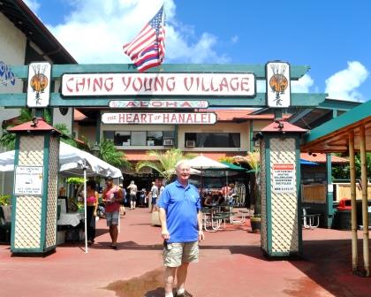
The Heart of Hanalei
But alas! We could not find Tunnel Beach. Later, we were told you can only get there by a walk on the beach from Ke’e. So we gave up.  On romantic Hanalei Bay, the Ching Young Village is a favorite stopping point. We sat down at the ubiquitous LL Hawaiian Barbecue to sample another local favorite. Wow! The pork laulau, pork steamed with luau or taro leaves, was delicious!

Kilauea Lighthouse
tandem bike
Next stop was Princeville where Kauai’s plush resort hotels like St. Regis, Westin, and Wyndham were located. At the entrance to the exclusive village is a huge water fountain with quite a statue of Neptune. Just before turning south on Kuhio Highway, we came upon the Kilauea Lighthouse, on a short spit jutting out from a high viewpoint.

It may still have been raining off and on. But we had a great start to our Hawaiian exploration. On our last day, we rented a tandem bike (I still cannot ride a bike) and traced the Eastern coastline from Pono Kai to Kealia Beach. Bill’s legs got a great deal of exercises!

at Kealia Beach
It may have been a wet Aloha to the Hawaiian Islands, but it was, as always, a great Aloha! After all, rain is just water from heaven. And in Hawaii, it isn’t wet-cold!