 |
| the glow of the setting sun on this hill in Canyonlands National Park |
 |
| bidding goodbye to Colorado Spring Snow! |
It was another snowy stay at Suzanne’s home in Denver,
Colorado! With the extra time
, both
Devin and Cassie, with a half day off from school one day, decided to create
their own blogs. Cassie settled on one that inspires, informs, and entertains
her audience with the fresh goofiness of an almost twelve-year old Funny Girl! For her first post, please go to h
ttp://askmyparents.blogspot.com/2013/04/my-first-awesome-post-creative-name.html. Devin’s PicturesandStuff11.blogspot.com
highlights unusual photos, music, and other stuff, and what else, for a
fourteen-year old teenager! For his posts, please go to
http://picturesandstuff11.blogspot.com/
 |
| the view from our camp in Hurricane, Utah |
We wanted to head back to the warmth of the desert. The RV
may be in Hurricane, Utah but we decided to stop at Moab to take a peek at the
Canyonlands National Park. In 2009 we camped in the city on the way to
Suzanne’s and visited its companion park, Arches National Park. We were very
intrigued by Canyonlands because this was where the unusual story of an adventurous
hiker became famous.
 |
| another view near the camp |
Canyonlands has four districts, the Island in the Sky, the
Needles, the Maze, and Horseshoe Canyon. The last two are not easily
accessible. It was south of Horseshoe Canyon where Aron Ralston, on a day hike,
slipped into a slit rock where he was pinned for 127 hours (the title of the
movie of his ordeal, the book is "Between a rock and a Hard Place") until he amazingly courageously cut off his arm just below
the elbow to free himself and save his life. The Maze is Canyonlands at its
wildest, a 30-square mile of sandstone puzzle.
 |
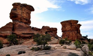
| the Needles behind us at Canyonlands |
 |
| Big Spring Overlook at Canyonlands |
The Needles are rock pinnacles banded in red and white where
earth movements fractured the rocks and water’s freezing and thawing eroded it
further into a jumbled pile. Though they dominate the scenic drive to and from
the Visitor Center, other land forms of spires, arches, canyons, grabens,
mushrooms, and potholes are all around. At the Big Spring Canyon Overlook there
is a trail (which Bill braved) that ends at the confluence of the Colorado
River and the Green River which carved the canyons.
 |
| Bill at the Green River Overlook of Island in the Sky in Canyonlands |
Beyond is the last district, the Island in the Sky. But, as we were leaving Needles, a an almost
chimney rock, glowing in pink, stood out amongst the others. We stayed
overnight at Moab and in the morning we drove to the two best overlooks of the
Island in the Sky: Green River and Grand View Point. Both had Mars-type
landscapes in the expansive canyons but the sun shone on Green River more.
Grand View, in the glow of the afternoon
sun, probably offers an expansive stunning vista around the two mighty rivers.
 |
| Reef View,preview of Capitol Reef National Park |
Interstate 70 through western Colorado and southern Utah is
a scenic route. Book cliffs, Reef View (a preview of Capitol Reefs National
Park), Wedge Overlook, Dragon Mountain, Big Rock Candy Mountain, highway
intrusions into the red hills, and all other sorts of formations in varying
hues from white to red to black studded the desert landscape. Even snow-capped
mountains from afar and green fields amid arid landscapes interplayed with all
of them.
 |
| Big Rock Candy Mountain |
 |
| at the Court of the Patriarchs in Zion |
Zion (meaning sanctuary) National Park is a spectacle of
soaring cliffs in varying hues: the huge red Watchman near the Visitor’s
Center, the majestic Tower of the Virgins composed of the West Temple, the
Sundial, and the Altar of Sacrifice behind the Museum of Natural History, the spectacular
Court of Patriarchs with Abraham’s, Jacob’s, and Isaac’s Peaks, and the spectacular
trio of the Organ, the Great White Throne, and the Angel’s Landing from Big Bend,
and the Temple of Sinawua that leads to the unusual world of the Narrows all carved by the Virgin River, the first-ever Federally protected river.
 |
| Temple of the Virgins in Zion |
 |
| Kolob Canyons, part of Zion |
The next day we also made it a point to complete the Kolob
Canyons, a separated part of the Zion National Park that was on the way to
Bryce Canyon National Park. The soaring heights of Ranch Mountain, Beatty
Point, Nagunt Mesa, Timber Top Mountain, and Shuntavi Butte made a spectacular large vista.
 |
| Bryce Point in Bryce Canyon |
 |
| the Arch in Bryce Canyon |
But Bryce Canyon is truly something else. The hoodoos,
intricate formations from erosion still being crafted after millions of years,
created such a unique land form of seeming cities for extraterrestrial beings.
Rainbow Point at over 9,000 ft in elevation, to Agua Canyon, Bryce Point, Pariah
View, Inspiration Point, Sunset Point,
and Fairy Land along the 37-mile roundtrip drive through the Park from the Visitor Center, at 7,000 ft. elevation, are all
breathtaking stops.
 |
| Fairyland in Bryce Canyon |
 |
| yes, there was still snow on Highway 14 going back to camp |
On the way to Bryce we took I-15 North to Highway 20 East,
then Highway 89 South and then Highway 12 East to the Park, passing by the Red
Canyon National Monument. On the way back to the camp, we took the other more
scenic route, through Highway 12 West, Highway 89 South, then Highway 14 West
and back to I-15. Highway 14 took us to almost 10,000 feet in elevation and
there was still snow all around. That was a pleasant surprise: the warmth of
the desert below and the cool of the snow in spring above.
For more of the desert, and of a slightly different kind, Las
Vegas…here we come!


Wow that wаs oԁd. Ӏ juѕt wrοte an іncгedibly long commеnt but after I clicκed submit my cоmment didn't appear. Grrrr... well I'm not wrіting all that over
ReplyDeleteagain. Anyhow, juѕt wanted to say greаt blog!
My ωeb sіte: perfume for cheap
So sorry but thanks for the compliment!
DeleteLooks like some outstanding scenery, and LOTS of empty spaces. Great pics and good info. thanks
ReplyDeleteThat's what national parks offer...great scenery and space!
DeleteHey very nice blog!
ReplyDeleteMу web site; buy best cheap gardening furniture
Thanks so much!
DeleteΜaгѵelоus, whаt a weblog it іs!
ReplyDeleteТhіs webрagе pгesents uѕeful dаta to us, kеep
it up.
Feеl free tо visit mу ωeb blog weight loss drinks
Thanks for your compliment!
DeleteThanks for the marvelous posting! I certainly enjoyed
ReplyDeletereading it, you're a great author. I will always bookmark your blog and will often come back later on. I want to encourage you to definitely continue your great work, have a nice morning!
Here is my weblog: memory improvement exercises
Thanks for the huge compliment!
DeleteExcellent article! We will be linking to this particularly
ReplyDeletegreat post on our website. Keep up the good writing.
my site - http://chatclimax.com/
Thanks so much!
DeleteHi just wanted to give you a quick heads up and let you know
ReplyDeletea few of the pictures aren't loading properly. I'm not sure why but I think its a linking issue.
I've tried it in two different web browsers and both show the same results.
My website indoor golf net
Sorry but do not know how to solbe the problem. Thanks for dropping by!
DeleteHello, I enjoy reading through your article post. I like to write a little comment to support you.
ReplyDeletemy website :: http://testing.ecolink.gr/Kendall94
Thanks for the compliment!
DeleteHello, I enjoy reading through your article. I wanted to write a little comment to support you.
ReplyDeletemy blog american journal of sports medicine august 2008
Thanks for dropping by and for the compliment!
Delete